
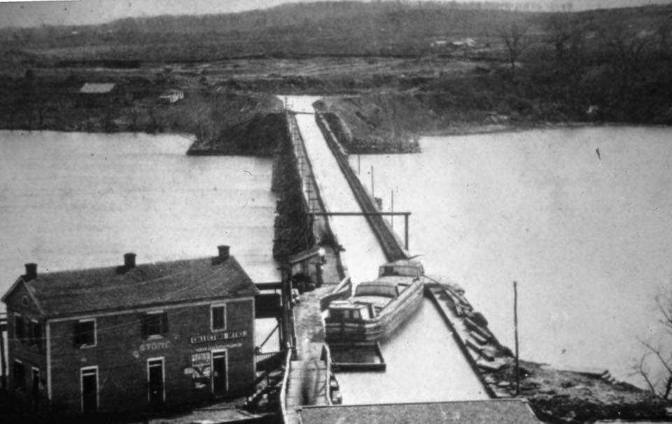
This week for Georgetown Time Machine, GM is exploring a fascinating photo that came to his attention care of the fantastic Old Time DC account (which you should follow if you love DC historical photos!) The photo shows the old Aqueduct Bridge that once stood between Georgetown and what then a rural part of Alexandria County.
The date of the photo is approximately 1860, which makes it a rather early photo of any part of Georgetown. And the best part is how it clearly shows the aqueduct bridge operating as its name suggests.
If you want a deep dive into the bridge’s history, read this fantastic article. But here’s a shorter version. The C&O Canal was partially constructed and opened by 1830. This brought a great deal of shipping to the Georgetown waterfront for transfer to ocean going ships. The port of Alexandria was cut out of this model, as it didn’t make sense to transfer goods from the canal to a river boat at Georgetown, only to transfer to another boat at Alexandria. So Alexandria lobbied to create a direct access from the C&O canal to Alexandria.
Since the C&O Canal is on the east side of the river and Alexandria on the west, it necessitated an aqueduct to cross the river. With Congressional funding, construction on the bridge began in 1833 and finished ten years later.
Of course, the plan also required a new canal to be built on the west side of the river from Georgetown down to Alexandria. That canal, the Alexandria Canal, was also built between 1843 and 1844. It can be seen in this 1878 map:

(Unlike the C&O Canal, nothing remains of the Alexandria Canal)
The first photo above shows a canal boat at the Georgetown end of the bridge. As for the building next to the bridge, it somewhat resembles the famous Key Mansion that was also near to the bridge, but it is not in fact the former home of Francis Scott Key.

This particular view of a canal boat waiting on top of the bridge to cross was not long for the world at the time of today’s photo. During the Civil War that broke out soon after, the federal government seized the bridge, drained the aqueduct, and used it as a wagon bridge. Following the war, the bridge was returned to its owners, who decided to reconfigure the bridge. A new structure was created on the abutments that put the canal passage on a lower level and kept the wagon bridge on the top level.

But this was not to last either. By the 1880s the government repurchased the bridge reconstructed it for the third and final time. This version was steel and had no aqueduct component and was opened in 1889.

(The Alexandria Canal was abandoned in 1886 seeing as it no longer served any purpose. It was converted to use as an electric railway, which itself was mostly abandoned by the 1960s. But a little of it remains as that part of the Blue Line that travels outdoors between Rosslyn and Pentagon City.)
The Aqueduct Bridge itself was replaced by the Key Bridge in the 1930s. The old piers remained into the 1960s, at which point all but one was demolished. The large stone abutment on the Georgetown side remains.


Pingback: Georgetown Time Machine | The Georgetown Metropolitan