
This week, WMATA floated what it is referring to as a “Draft Visionary Network” for its extensive Metrobus system. The plans would dramatically redraw the entire existing network across the whole service area. And consistent with that, the changes suggested by the plans would significantly impact bus service through Georgetown.
It’s important to state first that this is a very preliminary plan. It was drafted looking at the data and prioritizing faster services between the most frequented destinations. And WMATA is soliciting feedback from the public. One of the tools they released lets you plan a trip and see how your time would compare between the current network and the proposed one. (More on that down below).
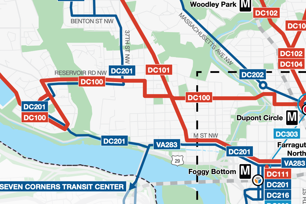
The new system would represent a clean break from the current one. All the old route names (including the historic streetcar route numbers) would apparently be tossed. In their place would be brand new route numbers consisting of the route’s origin jurisdiction and a three digit number (e.g. DC100, VA203, etc.)
Just for reference, here is the existing bus map for Georgetown:

The bus routes are as follow:
- 31,33 – The main Wisconsin Ave. routes that go either to Foggy Bottom or downtown, depending on which bus you catch
- D2 – The bus to Dupont Circle, which travels in a loop up to Glover Park and back. Through Georgetown it’s mostly on Q St.
- D6 – Long haul bus line that travels from Sibley to RFK. Through Georgetown it mostly overlaps with the D2, thus increasing the bus options between Georgetown and the Dupont Metro stop
- 38B – Orange Line With a View! This bus travels between Ballston and downtown. It travels along M St. in Georgetown
- G2 – This bus links two universities: GU and Howard. It winds its way through west Georgetown and then travels along Dumbarton and P towards Dupont, and beyond
- Circulators – Of course there are also Circulator bus routes (some of which are on the chopping block), but WMATA doesn’t control them and so are not part of its future network
As stated, none of these routes would, per se, remain. Some would largely remain under a new name. For instance, the 30 series buses would fall into the new DC101 line (DC’s Alternative Rock Bus Line!) It appears the DC101 line would travel to Farragut North. The 38B will also be largely replaced by the VA283.
Separately, the D2, D6 and G2 would effectively be merged into the DC100. This new line would start at Sibley, like the D6, and follow that bus’s route through Georgetown. However, instead of traveling along Massachusetts Ave., it would head down to P St. and travel east on that street until New Jersey Ave. At that point it would head south and terminate somewhere near Union Station.
This would basically mean the end of the G2 and any bus service in west Georgetown (and large stretches of east Georgetown). It would also dramatically change bus options for Glover Park residents. Instead of simply using the D2 to quickly head down to the Dupont Metro, they would take the new DC 201, which takes a circuitous route from Foggy Bottom along M and Canal to MacArthur, up around Reservoir Rd. until reaching the old D2 route. Instead of looping back around like the D2, this new route would continue northward to Tenleytown. (It should be said that this route would serve the new MacArthur High School, which will be woefully underserved by our current network).
The color of the line in the map above indicates whether it would be a high, medium or low service. Red, including the DC100 and 101, would be high service (supposedly every 12 min. or better). Dark blue, including the DC201 and VA283, would be medium (every 20 minutes or better). Light blue would be low service (every 30 min. or better).
Will these be changes for the better? That largely depends! For instance, if you mostly take the 31 to Foggy Bottom, then I would guess the DC101 would be pretty much the same. And that bears out in the comparison WMATA is offering. According to the planner, if you want to go from P and Wisconsin to the Foggy Bottom Metro it will take two minutes faster, supposedly:
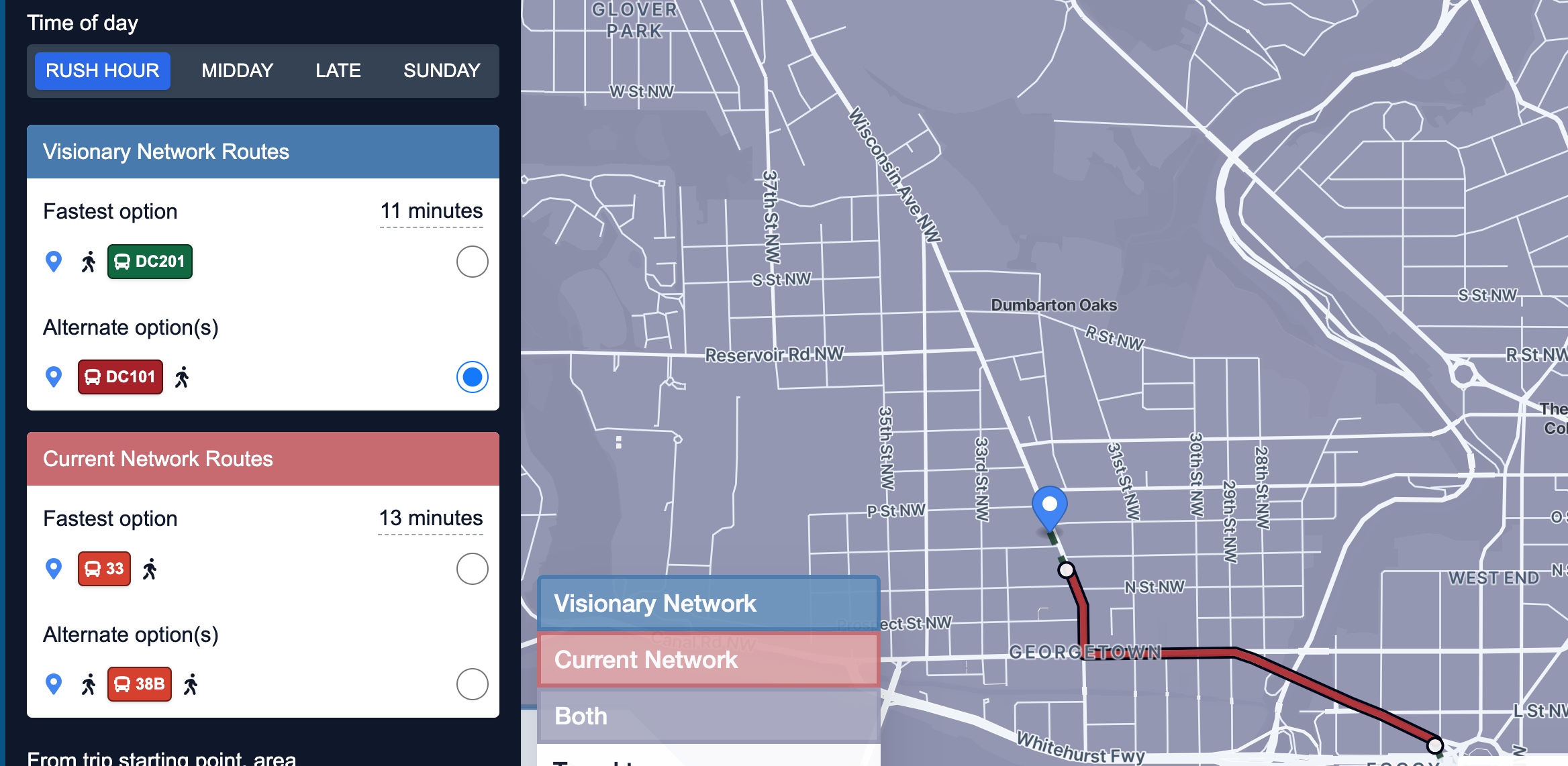
It’s not clear, but it appears the new bus line would reduce the number of stops dramatically, thus saving two minutes over the current route. Which is great, unless of course they eliminate your normal stop and you have to walk two (or more) minutes extra just to catch the bus in the first place.
But let’s say you have an efficient route right now that will clearly get inefficient with the new system. For instance, say you live at 29th and O and need to get to Dupont Circle. Right now it’s a nearly straight shot on the G2. But in the new system, you’d have to hoof it four blocks away, just to take a long bus ride:

It’s clear WMATA doesn’t like legacy bus routes like the G2. Budget cuts led it to be temporarily cut off at Wisconsin Ave. for a time. And it was set to be dissolved due to additional cuts during the height of the pandemic in much the same manner as this vision puts forward. So it may be a tough battle to keep it in the future. But frankly I am of the view that conveniently located lines often trump slight improvements in travel time. So, at least for my part, I will be pushing to keep as much of the current network as possible. But perhaps you feel differently. Either way, please weigh in with WMATA!


Pingback: May ANC Update! | The Georgetown Metropolitan
Pingback: ANC Meeting Tonight | The Georgetown Metropolitan
Pingback: Bus Overhaul Proposal Released | The Georgetown Metropolitan