
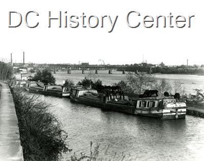
This week for Georgetown Time Machine, I’m sharing another photo from the DC Historical Society. It’s of the canal at a time when it was still a functional canal.
According to the record, the photo was taken sometime between 1910 and 1920. You can see the old Aqueduct Bridge in the distance, which places the location up the river a bit from Georgetown. In fact, I think there are parts of the Three Sisters Islands on the right, which would put the location on Canal Road immediately west of its split from Foxhall.
The photo description states that the boats are waiting to be unloaded, although to be honest, they don’t look exactly overladen with materials. By this time, the canal was primary being used to transport coal from West Virginia. But even this usage represented the twilight time for the canal as a functioning supply route. The last boats to actually use the canal to transport goods ran in 1924. A storm later that year damaged much of the canal and spelled the end of the canal as a viable trade route.
The section of canal shown in the photo above has been a grassy field for the last several years. This is due to the the water being “turned off” in order to facilitate canal wall repairs in Georgetown. Hopefully once those are completely, this section can be watered again and the new canal boat tours can come up and at least partially recreate this photo once again.


You must be logged in to post a comment.