This week for Georgetown Time Machine, I’m exploring a story that at first glance seemed to be a story about whether preservation rules are too strict but actually turned into a wild history of police chiefs getting bitten and WWII era latin jazz.
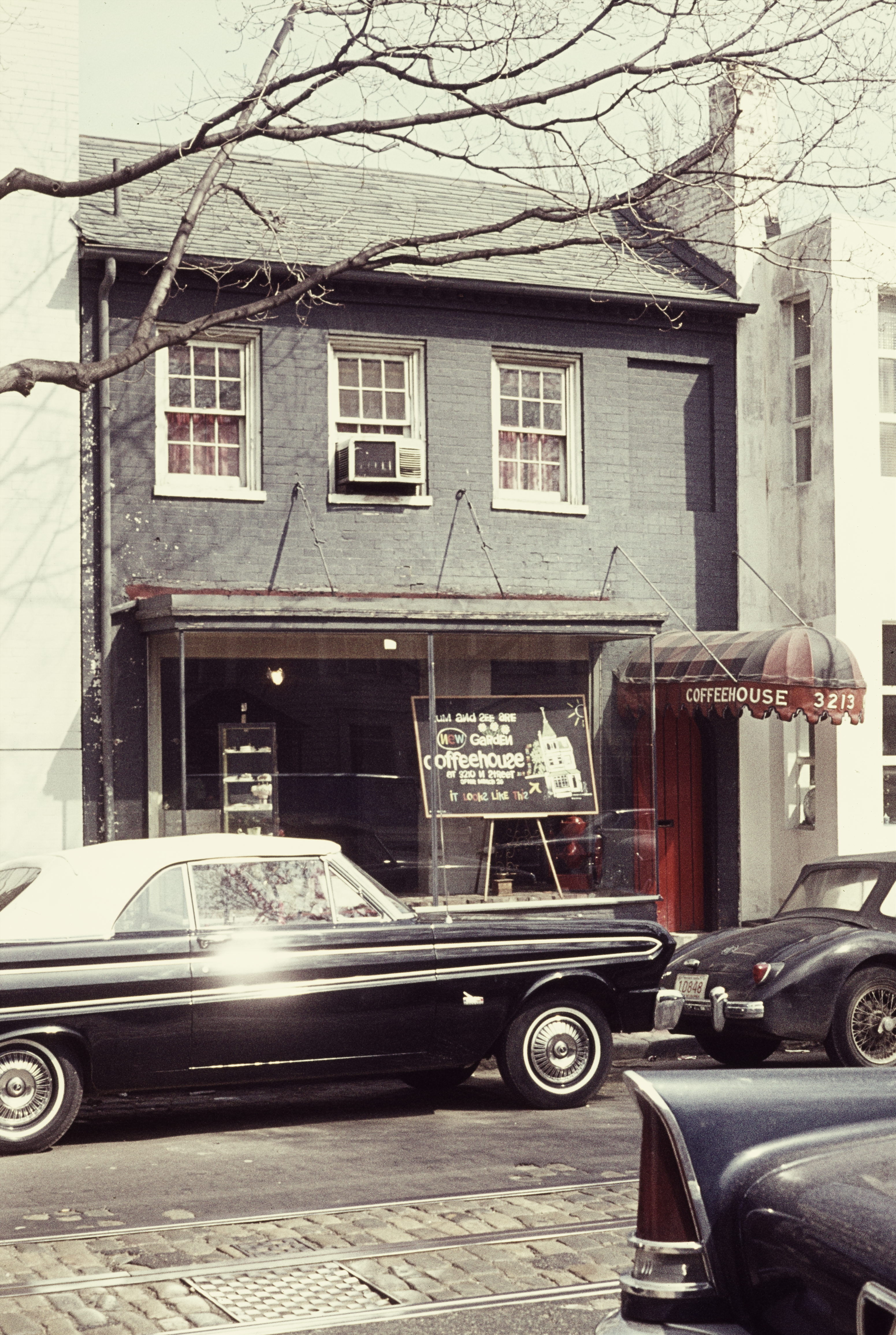
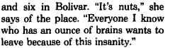
But lets start with the seemingly innocuous photo. It comes from the DC Historical society. It’s from the Emil Press collection and was taken around March of 1964. It shows 3213 O St. which at the time was a former coffeehouse named Gallery. It operated here (with “red jacket waiters sedately serving cappuccino and darjeeling” according to the Washington Post) for seven years.
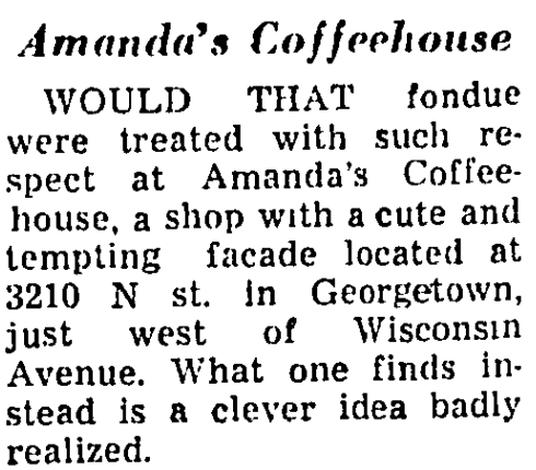
The owner, Amanda Goudie, decided in 1964 to pick up sticks and open a new coffee shop a block away at 3210 N St. You can see the announcement in the window of the coffeeshop intentionally(?) misspelled:
cum and see are new garden coffeehouse at 3210 N St. It looks like this-> (with a drawing of the new location).
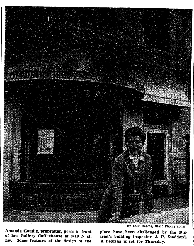
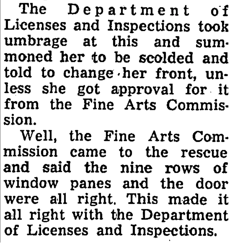
That new location, however, would turn out to be a big headache for Ms. Goudie. According to a Washington Post article from a couple months later, she got into some serious trouble with the preservationists:
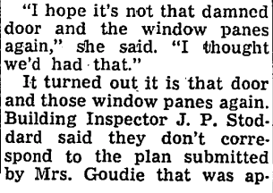
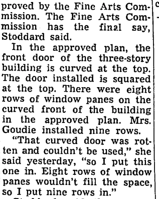
Apparently she needed to do some work on the new location, including fixing the door. According to the article, the plans she got approved by the CFA included one design for the door, but she installed a different one. This lead to a summons from the DC government. She was nonplussed:
She was due to appear before the DC government and account for her actions two days after this article appeared, but at the last minute the CFA came to her rescue:
Sadly for Ms. Goudie, this small victory did not save her from being savaged by the Post a few years later when her shop chased the fondue craze:
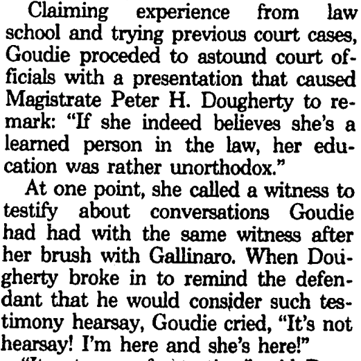
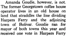
I’m not sure when the shop closed, but Ms. Goudie eventually made her way to Harpers Ferry, WV where she opened another coffeehouse. She also appears to have become a bit of a local gadfly. After a violent run in with the police chief in which she apparently bit him, she stood trial and acted as her own lawyer. It was, as it always is, a mistake:
She was fined $500 and then promptly announced she was running for mayor. She got seven votes.
Another source states that before all this, she sung under the name Amanda Lane with the Desi Arnez Band. Here she is singing East Street in 1946:
It’s pretty incredible sometimes what stories you uncover when you start digging around a completely innocuous photo of a closed coffee shop…
For the record, 3210 N St. still has a window with 8 rows and a square-topped door.
This week on the podcast I’m talking about some major changes that are coming to the western end of Water St. and how once significant flaw will remain until we come up with a solution.
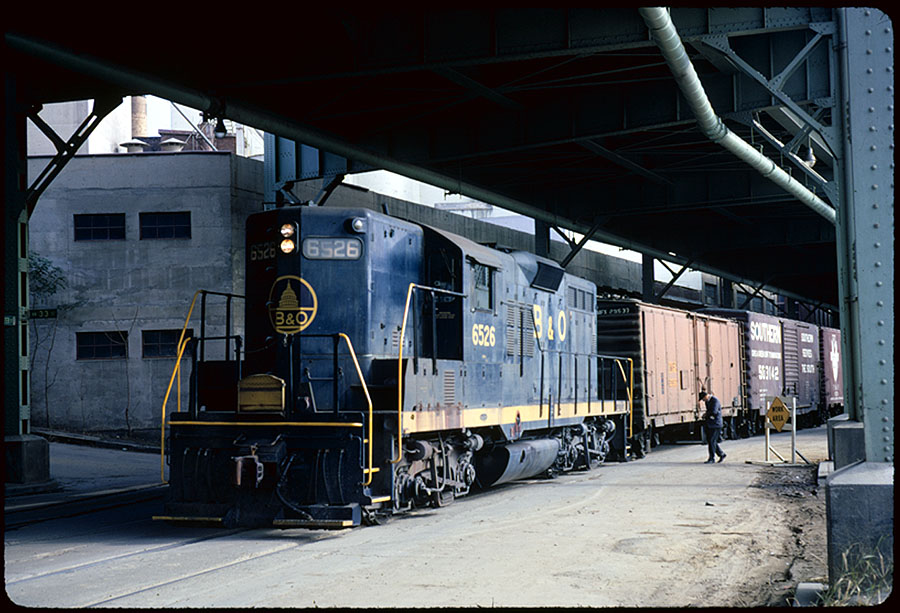
The Department of Parks and Recs will be holding a final public meeting for the proposed renovations to Book Hill Park. The meeting will take place at the Georgetown Library at 6 pm on April 13th. The city reps will be presenting the final designs and construction logistics. Come on out and learn what’s in store for the park!
Hello and welcome to your April Northwest Georgetown ANC update! And happy spring!
Resident Only Parking Update
At the March ANC meeting, the commission adopted a resolution stating our intention to pursue a request to the city to evaluate and implement resident only parking (ROP) in Georgetown. As we discussed at the meeting and in the resolution, the process as described to us by the Department of Transportation (DDOT) is this:
The ANC will generate a map of blocks within the ANC that we would like DDOT to consider for ROP.
We will submit this map informally to the DDOT staff for pre-review.
This pre-review is designed to make sure that the blocks we are requesting are feasible for the study and implemenation.
This process may require the exchanging of a few drafts until we reach a suitable map.
At that point, the ANC will consider the adoption of a formal resolution requesting that DDOT study and implement ROP on the blocks of that map.
Following that resolution, it will be in DDOT’s hands. The regulations state that they need to conduct a study of the blocks under consideration. The staff must observe that the blocks are 85% full with at least 50% of the cars not having Zone 2 parking permits. As mentioned in the March ANC meeting, this may require some amount of pressure from the ANC to make sure these observations are done during appropriate hours, not, say, 7:00 AM on a Saturday morning.
As for the map, for my part, I intend to submit all the blocks in my SMD for consideration. As a reminder, here is my SMD:
If you feel strongly that you do not want your block considered, please let me know! I have received fairly overwhelming support for this idea from constituents so far, but if you and your immediate neighbors feel different, I want to hear from you.
I’ll keep you informed as the process continues.
Volta Park
After a frustrating delay in active work, the construction at Volta Park has been making progress over the last month or so. I believe the irrigation work is complete or nearly so. The field has been scraped of the old topsoil in preparation of the installation of the sod. I’ve been told they are targeting a May finish date. I hope that’s accurate, but I’ve seen too many deadlines pass unfulfilled to put too much weight on that. We’ll see!
Speaking of Volta Park: Mark your calendar for the Friends of Volta Park’s always excellent Spring cocktail party! June 4th!
Podcast:
If you’re reading this update, then you probably also get the podcast I started up. I hope people enjoy it. It’s fun for me to make and even if it’s hardly going to be the next The Daily, or whatever.
Please let me know if you have topics that you’d like me to explore. So far the ideas have come to me in time to make my weekly(ish) target, but I’m sure the ideas may dry sooner or later. If there’s some Georgetown-related topic you’d like to know more about or want more people to know about, let me know!
Just a reminder, you can subscribe for the podcast through Apple podcasts or Spotify.
Quick Notes:
Here are a few items from the last month you may have missed:
Longtime owner and editor of the Georgetown Current, Davis Kennedy, passes away.
This week on the podcast, I’m discussing coffee shops and Georgetown, including two new shops on the way, how the number of shops have fluctuated over the years, and the intriguing story of Georgetown’s proto-beatnik coffee house from the 1930s.
The Wall Street Journal had an interesting article this week exploring how across America last year, landlords leased more space to service businesses than to businesses selling stuff. Among the most common service businesses were spas and gyms.
That got me wondering: does Georgetown match this trend? I do an annual(ish) survey of all the stores and businesses in Georgetown. I can figure out how many are service oriented and how many are retail. While I can’t use square-feet leased as a metric the way the WSJ study does, it’s at least a thumbnail stab at the question.
So here goes!
Here’s my most recent chart showing the breakdown of categories of all the stores and businesses in Georgetown:
That might be a bit hard to make out, so here is the summary information:
Among all businesses in Georgetown:
Non-Service are 78%
Service are 22%
So Georgetown is nowhere near the same as America writ large, which should probably not come as a surprise.
Out of curiosity I ran the numbers without considering food or drink establishments. This compares strictly stores that sell pure services and stores that sell pure stuff (that you don’t put in your body). The totals were closer to eachother:
Non-Service are 68%
Service are 32%
So despite the fact that it seems like there are a million hair salons, and gyms, and yoga studios, and fortune tellers, and tailors, and etc., Georgetown’s still got a whole lot of other types of stuff too.
A new shop that specializes in bikini swimsuits is coming to Wisconsin Ave. The shop, Frankies Bikinis, is set to open at 1240 Wisconsin.
Here is their website if you want to give yourself some body-image issues. They’ve got everything from extremely skimpy swimsuits to extremely skimpy swimsuits that look more like lingerie. What range!
I guess I should’t be too surprised, what with them being pretty upfront about being a bikini shop. Fun fact: nobody is really sure why exactly swimsuits like this are called ‘bikinis’ in the first place. Obviously they’re named after the Bikini Atoll where they (the U.S. Government, not Frankies Bikinis) tested the atom bomb.
But beyond that it’s all speculation as to whether they (the ‘they’ is this case being the French designers that first came up with the style) wanted to evoke the power of 23 kilotons of dynamite or just the vague idea that island girls are just skipping around with barely any clothes on. Neither lacks for a bit of awkwardness by modern sensibilities, but luckily no one thinks about that too much.
The shop was started by a mother-daughter team in Malibu: Mimi and Francesa Aiello. Hence ‘Frankie.’ Although come to think of it, the store is “Frankies” not “Frankie’s”. That makes me wonder where is the other Frankie(s) and what did they do with him, her, or them?
No word on this other Frankie(s) or when the store is going to open.
This week on Wisconsin and M I’m talking about Georgetown’s surprising history as the birthplace of a bunch of big companies. Listen to the episode here, or at Apple podcasts or Spotify.


.png")


You must be logged in to post a comment.