Friends of Volta Park’s annual spring cocktail party fundraiser will be held at the George Town Club on Saturday June 1st. from 4:30 pm to 6:30 pm. Tickets (including raffle tickets!) are available for purchase here.
This is one of the most important fundraisers of the year for FOVP and always a great time for all the neighbors. So come on out!
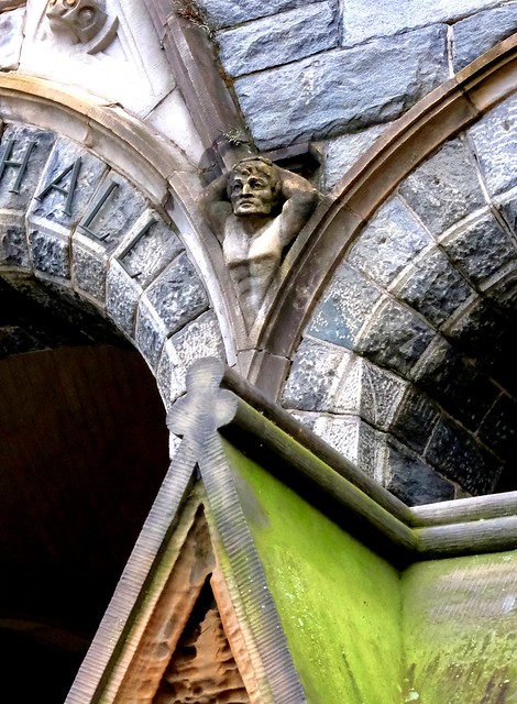
This week for Georgetown Time Machine, I’m exploring an interesting image that gives a glimpse of an entirely vanished part of Georgetown’s past. In the words of its description:
Barn On Georgetown Heights A View of 2 Barns And Fencing. One Barn At the Left Has a Small Extension Attached To It. Barn At Right Sits Atop Wall Footings, Creating an Open Space Below It.
The drawing comes from the Winfield Scott Clime collection at the DC Historical Society. It is dated to June 29, 1913.
Of course I immediately wondered where exactly this is depicting. Georgetown Heights could mean a couple different places. Firstly, it can refer to the northeastern parts of Georgetown proper, basically north of Q St., east of Wisconsin Ave. But I’m not sure there were barns up in this part of Georgetown that late. Here’s a map of the area a few years later in 1919:
It already had the urban layout that it carries to this day. So it doesn’t seem too likely that the barns were here (of course it’s possible, just not likely).
The other more likely possibility is that this was actually somewhere in what we now call Burleith or Glover Park. Before these neighborhoods were developed as neighborhoods in their own right, they were simply the rural outskirts of Georgetown. And it would be perfectly normal to refer to these hinterlands in 1913 as Georgetown Heights.
Despite this conclusion, this drawing nonetheless offers a fascinating window into Georgetown’s rural past. While the main part of Georgetown was pretty much always developed with an urban form, the areas outside the central part were quite rural at times. There were even small farms west of Georgetown University into the 20th century. This drawing takes us to those days.
Yesterday, I discussed the changes proposed to three bus lines in Georgetown–the D2, D6, and the G2–as part of the Better Bus Initiative. Today I will discuss the other changes that would touch on bus service in Georgetown.
Probably the most busy and important bus lines through Georgetown are the 30-series routes. These routes–which travel along Wisconsin and M St. in Georgetown–used to routinely stretch all the way from Friendship Heights to southeast DC. For efficiency’s sake, WMATA has segmented those lines more and more over the past 10 years or so. Prior to covid, there were still at least a few buses an hour that would traverse the whole city, but now there are none. All 30-series routes now travel only as far as Foggy Bottom or downtown.
So as of right now there are two 30-series that run through Georgetown: the 31 and the 33. The former goes to Foggy Botton and the later goes to Federal Center, by way of downtown. From the perspective of Georgetown, these routes would be replaced by a single route: the D82
Here is the proposed route for the D82:
Like the 31, this line would get you to Foggy Bottom. But it would lose the direct connection to the Foggy Bottom metro station that now exists. The 31 delivers you just steps from the entrance. The D82 would require more like a block or two walk.
And like the 33, it would also get you to downtown, although not all the way to Federal Center as the 33 does now:
A chunk of the 33 seems to have been incorporated into the new D12 route:
But since it only goes as far as Foggy Bottom/Kennedy Center, it’s probably not of great use to Georgetowners.
So for analyzing services levels, it’s fair to compare the combined 31 and 33 to the new D82. And here are the proposed headways for the D82:
Here’s how they compare with the existing service:
Early morning:
Current service: Every 12-20 minutes
Proposed service: Every 20 minutes
Morning rush:
Current service: Every 8-10 minutes
Proposed service: Every 6-10 minutes
Midday:
Current service: Every 10 minutes
Proposed service: Every 10 minutes
Afternoon rush:
Current service: Every 10 minutes
Proposed service: Every 6-10 minutes
Evening:
Current service: Every 10-15 minutes
Proposed service: Every 12 minutes
Overnight:
Current service: Every 20 minutes
Proposed service: Every 18 minutes
So depending on the details, for most of the day the proposed service would match or exceed the existing service. Before morning rush and after evening rush there may be a slight reduction in service, but it’s not significant.
So for Wisconsin Ave. bus service, the new route would largely meet or exceed the current routes. The only real clear loser would be someone who uses the 33 right now to get all the way to Federal Center. But I can’t imagine that is a large number of people.
There is a huge, blaringly red asterisk on this analysis: the Circulator. Right now that the Circulator supplements service between Georgetown and downtown. Right now the mayor is proposing ending the entire service. The Better Bus Network as proposed would not replicate the Georgetown-Union Station Circulator route. The council has not signed off on that budget yet. And at least one councilmember (Pinto) has expressed a desire to either keep the Circulator or insist that its service be incorporated into WMATA’s. So stay tuned on that angle.
But that’s not all! Another Georgetown bus route impacted by the proposed changes is the 38B. This route (once called “the Orange Line with a view”) travels from Farragut Square out to Ballston by way of M St. through Georgetown. It would be replaced by the A58.
Unlike the 38B, it would travel all the way out to Seven Corners. But for the most part, it would simply mimic the 38B.
In April 2023, WMATA released a draft plan to dramatically redesign the Metrobus network. As I wrote back then, this could significantly impact (and degrade, in my opinion) bus service through Georgetown. The headline changes included essentially eliminating the G2 route and then merge the D6 and D2 routes into one hybrid route. The plan did not release specific headway numbers (i.e. the length of time between buses) but with the reduction in lines, it seemed reasonable to conclude that the aggregate amount (and thus frequency) of buses through Georgetown would be reduced.
WMATA has now released an updated and clarified version of the new network. Here is how it would impact Georgetown:
WMATA is no longer proposing to merge the D6 and D2 into one route. It is now subsuming the D2 into a rather length new route called the D96:
Between Dupont and Burleith it would essentially follow the same route as the D2 (with a few tweaks to the route on the Dupont side). But east of Dupont it would go all the way to the mall by-way of 19th St. (Although on weekends, the bus would turn around at Dupont).
North of Burletih, the bus would continue up through Glover Park to New Mexico Ave. up to American University. From there it would jog over to Massachusetts Ave. to Western Ave. and then onward to Friendship Heights and ultimately downtown Bethesda. Frankly it is a fascinating route to consider. I don’t believe there has ever been a one seat ride from Georgetown all the way to Bethesda before. But my worry with such a long route is that it can lead to delays and bus bunching.
For what it’s worth, this is the proposed headway for the new D96:
Right off the bat, that is on its face less service than the D2. Here is a direct comparison:
Early morning:
Early Morning:
D2 – Every 20 minutes
D96 – Every 30 minutes
Morning Rush:
D2 – Every 10 minutes
D96 – Every 20 minutes
Midday:
D2 – Varies but roughly every 25 minutes
D96 – Every 30 minutes
Evening Rush:
D2 – Varies between 12-15 minutes
D96 – Every 25 minutes
Evening:
D2 – Every 20 minutes
D96 – Every 25 minutes
Late night:
D2 – Every 45 minutes
D96 – Every 30 minutes
So for just about every time of the day except late night, the D96 would offer longer waits between buses. This is especially true for morning rush. The difference between every 10 minutes and every 20 minutes is huge. That’s the difference between six buses an hour and three.
But it’s probably not accurate to consider only a D2 v. D96 comparison. That’s because the other new routes overlap quite a bit. And the first other one to consider is the proposed D94:
The D94 is essentially the western half of the existing D6. It is identical between Sibley and Rock Creek. But east of Rock Creek it takes a different route through Dupont and heads south in order to take advantage of the bus lanes on H and I streets. It eventually winds its way down to Chinatown before heading back.
Bike to Work Day this Friday! (Just an aside, but given the move away from working in the office on Fridays, I would suggest that Bike to Work Day should maybe be moved to a midweek day?)
Last week, the city hosted the final public meeting on the proposed renovation of Jelleff Recreation Center. The Georgetowner had a great write-up of the meeting, and I encourage you to read it. But I wanted to share the plan images themselves. So here you go!
First the renderings of the external elements. You can see it includes several new features, including:


You must be logged in to post a comment.